History
The Mettur Dam, a symbol of engineering marvel and vital source of water for Tamil Nadu, boasts a rich history dating back to the early 19th century. Here's a comprehensive look at its journey:
Early Proposals (1834): The need for a dam across the Kaveri river to regulate water flow and prevent flooding was recognized as early as 1834. However, concrete plans only materialized much later.
The Visionary Engineer (1924): The credit for initiating the Mettur Dam project goes to Vincent Hart, an Irish engineer serving as the chief engineer of the Madras Presidency. Recognizing the immense potential for irrigation and power generation, he championed the dam's construction.
Building a Giant (1925-1934): Construction began in 1925, a monumental undertaking that took nine long years to complete. A workforce of 17,000 labored tirelessly to build this massive structure. Funds were sourced from taxes collected in the Madras Presidency.
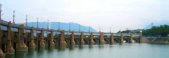
A Momentous Inauguration (1934): On August 21, 1934, the dam was inaugurated by the Governor of Madras, Sir George Stanley. The reservoir formed behind the dam was named Stanley Reservoir in his honor.
Mettur Dam Park
The Mettur Dam Park is a beautiful green space located right in front of the majestic Mettur Dam in Tamil Nadu, India. It's a popular spot for locals and tourists alike to relax, enjoy the scenery, and have a picnic.
Here's what you can expect at Mettur Dam Park:
Lush greenery and walking paths: The park is well-maintained with plenty of trees, flower beds, and walking paths. It's a great place to take a leisurely stroll and enjoy the fresh air.
Children's play area: The park has a dedicated play area with swings, slides, and other equipment for children to enjoy.
Food and drinks: There are a few small shops selling snacks and drinks inside the park.
Scenic views: The park offers stunning views of the Mettur Dam and the surrounding hills. You can also see the Cauvery River flowing downstream from the dam.
Boating: Boat rides are available on the Cauvery River near the dam, offering a different perspective of the area. (Note that boating might be a seasonal activity, so check before you go)
Fish food: A fun activity for visitors, especially children, is to buy fish food from vendors outside the park and feed the fish in the river.
Mettur Dam Timings and Fees
Entry Fee: There is a small entry fee of ₹5 (around 7 US cents) to enter the park.
Timings: The park is open all days of the week from 9 AM to 6 PM.
Location: The Mettur Dam Park is located in Mettur, Salem district, Tamil Nadu. It is about 100 km from Salem city and 300 km from Chennai.
Mettur Dam: Across Which River Does It Flow?
The grand Mettur Dam, Tamil Nadu's largest, tames the Kaveri River, a vital artery for the state's agriculture. Built in 1934, it took nine years to complete and forms the Stanley Reservoir. This dam's height and width are a staggering 214 and 171 feet respectively. It provides irrigation to a vast area and generates hydroelectric power. Mettur's water levels are crucial, and its releases determine cropping patterns for many.


 Click it and Unblock the Notifications