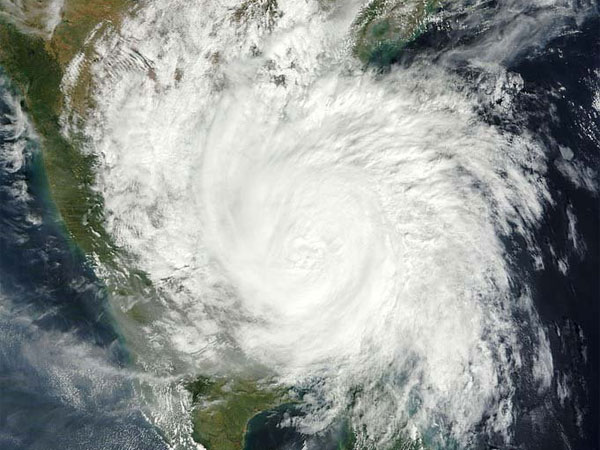
Weather forecast: Cyclone Fani likely to bring heavy rains near Andhra coast, Bengaluru
New Delhi, Apr 30: Extremely Severe Cyclonic Storm Fani has been brewing in Bay Bengal for quite long now. The journey started on April 25, when a low pressure had developed in Southeast Bay of Bengal and adjoining Equatorial Indian Ocean. Now, the Extremely Severe Cyclone Fani is gradually coming closer to the coast and is all set to make landfall over Odisha coast. Meanwhile, let us have a look at the weather forecast for Bengaluru, Delhi, Odisha, Andhra Pradesh and Jammu and Kashir, Uttarakhand and Himachal Pradesh on May 1.

Bengaluru:
Bengaluru rains have made a comeback, all thanks to the Very Severe Cyclonic Storm Fani over southwest and adjoining southwest Bay of Bengal. The city received moderate to heavy rainfall over a short period of time on Tuesday evening due to the impact of Cyclone Fani over Bay of Bengal. Indian Meteorological Department (IMD) has forecast moderate to heavy rainfall with thunderstorm activity for the next two days for the city and south interior Karnataka. As per Skymet weather, in the next 24 hours, there might be cloudy sky but chances of rains after 24 hours would decrease. Warm afternoons would also make a comeback.
Delhi:
Delhiites might get some relief from the sweltering heat on Wednesday as the weatherman has forecast thunderstorm and dust storm in the national capital. It was a warm Wednesday morning with the minimum temperature settling at 24.4 degrees Celsius, normal for this time of the year. Humidity was recorded at 49 per cent. The weatherman has forecast mostly sunny skies on May 2. The maximum temperature is likely to settle around 39 degrees Celsius.
Mumbai:
Pre-Monsoon rains and thundershowers in Mumbai and Konkan region are most likely to make a comeback soon. According to Skymet Weather, a cyclonic circulation is likely to form over Northeast Arabian Sea off Konkan region. With this, conditions would become favourable for some rain and thundershowers over the coastal areas like Mumbai, Thane, Dahanu, Ratnagiri and Sindhudurg. Since these would be pre-Monsoon activities, it would not have much impact on the day maximums. Unlike rest of the country, Mumbai and adjoining areas do not see much of pre-Monsoon activities. Pre-Monsoon rains in Mumbai only pick up pace around the onset of Southwest Monsoon that normally happens somewhere around June 10.
Andhra Pradesh:
During the last 24 hours, the southern parts of Andhra Pradesh such as Kurnool and Anantapur, witnessed good spell of rain and thundershower activities accompanied with strong gusty winds in the wake of the approaching Extremely Severe Cyclone Fani. Now as the Extremely Severe Cyclone Fani over west-central and adjoining the southwest Bay of Bengal is nearing the Andhra Pradesh Coast gradually, rain intensity and spread will also increase. In fact, the coastal stations of Andhra Pradesh are expected to witness widespread rain and thundershowers during the next 24 hours. Interiors of the state may also observe spell of rains. Thereafter, by May 2, as cyclone Fani will reach further north and start re-curving towards north/northeast, it will be closest to North Andhra Pradesh Coast. Thus, tomorrow we expect heavy to extremely heavy rains to lash the north-coastal districts of Andhra Pradesh such as Srikakulam, Vizianagaram, Visakhapatnam, Kakinada, Tuni and Amalapuram.
Jammu and Kashir, Uttarakhand and Himachal Pradesh
Scattered light to moderate rainfall activity occurred over Himachal Pradesh and Uttarakhand during the last 24 hours. Jammu and Kashmir also observed few isolated spells of rain. As per Skymet weather, on and off rain and thundershowers is expected with isolated snowfall to continue over Jammu Kashmir, Himachal Pradesh and Uttarakhand till May 3. Rains are now going to increase over the hills of North India. However, the intensity will remain mainly light with one or two moderate spells in the higher reaches.
Odisha:
The Extremely Severe Cyclone Fani is gradually coming closer to the coast and is all set to make landfall over Odisha coast. Cyclone Fani is expected to cross Odisha coast near Satpada and Balukhand area in Puri district around afternoon of May 3. State and national authorities have already put Odisha on alert against inclement weather conditions. All three forces Army, Air Force and Navy on stand by for joint operations across to be affected states of Odisha, Andhra Pradesh and West Bengal. As per Skymet weather, places in South Coastal Odisha like Gajapati, Ganjam, Khordha, Rayagada, Kandhamal and Koraput would start receiving heavy to very heavy rains. Eventually, the spread of rains would increase and cover parts of North Coastal Odisha. Most of the coastal stations such as Puri, Bhubaneswar, Kendrapara, Balasore and Bhadrak would start receiving heavy rains.


 Click it and Unblock the Notifications