‘Kyarr’ intensifies into 'very severe cyclonic storm'
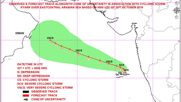
New Delhi, Oct 26: 'Kyarr', which was a deep depression in the Arabian Sea off-Goa coast , has now intensified into "Very Severe Cyclonic Storm".
The Indian Metreological Department (IMD) said that in the next 24 hours it may intensify into an extremely severe cyclonic storm.
"Severe Cyclonic Storm 'Kyarr' intensified into Very Severe Cyclonic Storm over eastcentral Arabian Sea. To move west-northwestwards towards Oman coast during next 5 days. Very likely to further intensify into an extremely severe cyclonic storm during next 24 hours,".

‘Kyarr’ intensifies into Very Severe Cyclonic Storm
Indian Meteorological Department has predicted heavy rains and gusty winds over coastal districts of Karnataka, Goa and south Konkan.
Meanwhile, rain lashed parts of Udupi earlier today. India Meteorological Department (IMD) had yesterday issued warning of light to moderate rainfall over coastal districts of Goa, Karnataka and south Konkan.
Kyarr's upgradation as a deep depression was a formality given that it had developed ample traction in a supportive environment, before being declared as a cyclone on Friday morning. (Image courtesy - Twitter/@Indiametdept)

Kyarr's position as of Oct-25 night
The IMD had on Thursday advised fishermen not to venture into the East-Central Arabian Sea during the next three days. They should not venture out along and off the Maharashtra-Goa-Karnataka coasts and the North-East Arabian Sea and the adjoining South Gujarat coast until Saturday. (Image courtesy - Twitter/@Indiametdept)

Fisherman have been warned
"Severe Cyclonic Storm ‘KYARR' over eastcentral Arabian Sea moved northwards and lay centred at 2030 hrs IST of today, the 25th October, 2019 near latitude 16.3°N and longitude 71.7°E over eastcentral Arabian Sea, about 190 km nearly to the west of Ratnagiri (Maharashtra)," IMD Weather twitter handle tweeted in the wee hours of Saturday. (Image courtesy - PTI/ File photo)

Kyarr's position as of Oct 25
Earlier, the Met department had issued a red alert along the coast of Goa, Maharashtra and Karnataka for the next two days. "The storm is very likely to move east-northeast-wards till the evening of October 25 (today). Then it is very likely to recurve and move nearly westwards towards south Oman and adjoining Yemen coast with gradual intensification during subsequent 72 hours," the department had said earlier.
IMD's Goa observatory issued an advisory saying tourists should avoid visiting the coastal state till October 27. (Image courtesy - Twitter/@Indiametdept)
How are cyclones named?
Cyclones and hurricanes that create havoc and destruction and even those that don't, are often given peculiar names like 'Fani', 'Titli', 'Laila', 'Helen' etc. Have you ever wondered on how these are chosen and why?
The tradition started with hurricanes in the Atlantic Ocean, where tropical storms that reach sustained wind speeds of 39 miles per hour were given names. Incidentally, hurricanes, typhoons, cyclones are all the same, just different names for tropical storms in different parts of the world; Hurricane in the Atlantic, Typhoon in the Pacific and Cyclone in the Indian Ocean.
Why are cyclones named?
The practise of naming tropical cyclones help in the quick identification of storms in warning messages because names are presumed to be far easier to remember. Naming cyclones helps to identify each individual tropical cyclone, makes it easier to report on them, heightens interest in warnings, increases community preparedness, and does not confuse the public.


 Click it and Unblock the Notifications


